NEW SOFTWARE RELEASE FOR B&G ZEUS & VULCAN CHARTPLOTTERS
Apr 3, 2018
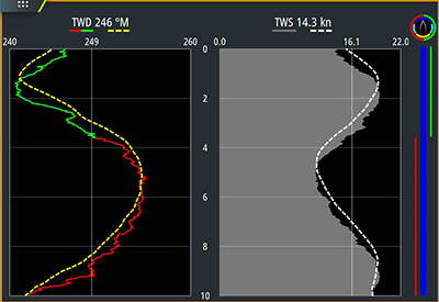
WindPlot Dual Mode view. Showing tack color coding and Tack bar (right) feature
B&G, the world’s leading sailing navigation and instrument specialist, has announced the release of a new software update for Zeus³, Zeus², Zeus² Glass Helm and Vulcan Series displays. This new software includes exciting new features, such as Advanced WindPlot, Device Registration and C-MAP® charting improvements.
Advanced WindPlot
WindPlot is available on the B&G Zeus and Vulcan series of products and allows users to keep track of wind speed and direction. This new software release specifically designed to help understand recent changes in wind speed and direction. The updates to WindPlot are specifically designed to help understand recent changes in wind speed and direction. The updates to WindPlot are aimed at providing users with a clearer view of wind trends, easier comparison of True Wind Speed (TWS) to True Wind Direction (TWD) and better display in small panels for use alongside charts, RacePanel or SailSteer features.
An (optional) “tack bar” feature has also been added that clearly identifies point of sail (pre-start, upwind, reaching, downwind) along with the tack of the boat. The Dual Mode view can also color code TWD for port/starboard tack as shown below. Data values are logged and provided to the user as average values per tack, to aid awareness and calibration.
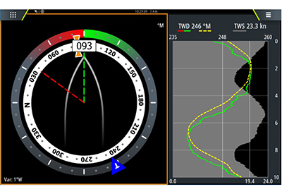 WindPlot Combined Mode view, for clear display alongside other panels
Device Registration
This latest software update also offers a new Device Registration option, designed to enhance user support. When a device is registered, future software updates will be sent directly through to the device when they become available, taking the hassle out of a previously manual process. There are two simple ways to complete Device Registration – during start-up, the device will prompt the user to register the product, or alternatively, the Device Registration set-up is located in the System settings dialog. To complete registration users need to connect their device to the internet or use a smart device with internet access.
C-MAP Navigation Palette
In addition to WindPlot and Device Registration, the new software includes enhancements to the C-MAP chart presentation with the introduction of a new palette that closely matches several common hydrographic office presentations. This update is most apparent near shore, where the colors used for land, docks, anchorage areas, water, and channels are nicely differentiated and water contour lines are distinct. The new palette makes it easier to see where the boat is in relation to a channel, ledges and drop-offs, or a point of land. The color scheme is also much easier on the eye.
AutoRouting& Easy Routing
Navionics’ Dock-to-Dock AutoRouting and C-MAP’s Easy Routing features are now available for use in U.S. territorial waters. Get faster and easier navigation with automatic route planning. This feature simplifies route creation by automatically plotting the shortest and safest course based on the boat’s draft, beam and height – creating a route around a landmass, shoals and other fixed navigational hazards. Dock-to-Dock Autorouting requires a Navionics+ or Navionics Platinum chart, while the Easy Routing is activated when using a C-MAP MAX-N+ map.
For further information on the B&G chartplotter series visit www.bandg.com

