Enhance your chartplotter experience with Garmin Navionics Vision+ premium marine mapping
Apr 17, 2023
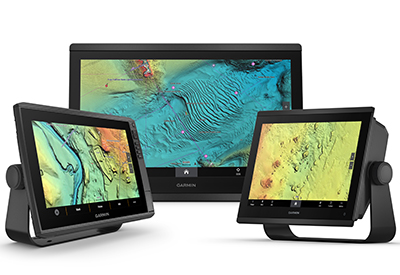
Garmin has announced expanded and enhanced high-resolution relief shading coverage to its Garmin Navionics Vision+™ premium marine cartography with 120% more relief shading coverage to deliver intricate and clear bottom structure detail to more coastal and inland waters around the world. Combining color and shadow, relief shading gives mariners an easy-to-interpret, clearer view of what’s below the surface than contour lines alone – now available on more than 40,000 additional lakes.
Available as an accessory card or download for compatible Garmin chartplotters, Garmin Navionics Vision+ gives boaters, anglers and divers access to an exclusive relief shading overlay. With expanded coverage of more than 120% from the previous charts, relief shading is available for many new coastal and inland waters, including lakes and rivers in the United States, Canada, Europe, Africa, Australia and New Zealand1. Garmin’s high-resolution relief shading is now even clearer in a vibrant new color palette with improved shadowing and better detail in many places on the shape of lake, river and ocean seabeds around the world, providing boaters a better understanding of depth changes at a glance.
“We’re constantly updating and improving our Garmin Navionics marine cartography to provide the widest range of coverage with unrivaled detail for our customers. Relief shading brings entirely new level of detail to the ocean floor and lake bottom to help in locating underwater structure, artificial reefs, underwater shelves and more – and we’re excited to bring this kind of detail to even more customers around the world.” – Dan Bartel, Garmin Vice President of Global Consumer Sales
A clearer picture of what’s below
Garmin Navionics Vision+ premium charts’ new color palette and image quality delivers a clear image of bottom detail that uncovers promising fishing spots, navigation channels and more. Multiple shading options aid in shallow water navigation, making it easier to choose depth ranges when searching for the best fishing spots. Additionally, numerous wrecks were targeted for enhancement to assist anglers and divers identify more precise spot-on-the-spot locations.
The relief shading feature must be downloaded via the ActiveCaptain® app available on Google Play or the Apple® App Store. Mariners can wirelessly connect their smart device to a compatible Garmin chartplotter to start the automatic transfer. The updated content is available for new and existing customers as part of their marine chart subscription.
Daily map updates
With up to 5,000 updates to map content every day, Garmin Navionics+ and premium Garmin Navionics Vision+ mapping offer fresh insights about covered bodies of water for enhanced situational awareness and peace of mind while navigating. The cartography is revised daily from public and private sources which includes proprietary surveys and Notice to Mariners to give mariners the most up-to-date information available from Garmin. With mapping coverage of coastal and inland waters worldwide, daily updates allow for immediate access to new content and chart data as it is updated. A one-year subscription is included and once activated, customers can access unlimited daily map updates using the ActiveCaptain app. For quick-and-easy access to ongoing updated content after the first year, customers can opt-in for an auto-renewal subscription.
Advanced autorouting technology
In addition to relief shading, Garmin Navionics Vision+ customers will also benefit from advanced Auto Guidance+ technology2 that combines the best features of Garmin and Navionics automatic routing solutions to provide a suggested dock-to-dock path to follow through channels, inlets, and marina entrances. After selecting departure and arrival points, Auto Guidance+ considers a variety of factors, such as overhead clearance, chart data, popular routes and desired depth—then creates a suggested route for mariners to follow to their destination.
Garmin Navionics Vision+ accessory cards and downloads are available now starting at USD $249.99. It’s compatible with many popular Garmin chartplotters, including the ECHOMAP™ UHD2, ECHOMAP Ultra, GPSMAP® x3 and GPSMAP 8400/8600 series. To learn more, visit garmin.com/marinemaps.
1Level of detail will vary based on the location and sources used.
2Auto Guidance+ technology is for planning purposes only and does not replace safe navigation operations.