C-MAP Updates Cartography for North America with Enhanced Imagery and Detailed Data
Mar 12, 2024
C-MAP® announced a major update to its North America charts, introducing detailed data for hundreds of lakes, improved satellite imagery, enhanced shaded relief and more.
“We are thrilled to roll out this new update to our C-MAP users in North America, significantly transforming their navigation experience,” said Jakob Svensson, C-MAP Product Manager. “Our product team is dedicated to sourcing new data and continually enhancing and improving our charts.”
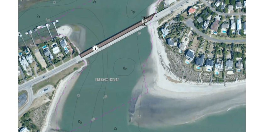
The new data includes Satellite imagery improvements in over 19 states including North and South Carolina and Washington. The popular Shaded Relief, exclusive to C-MAP REVEAL™ and REVEAL X, has seen improvements across more than 500 Lakes including the Great Lakes and coastal areas including the Bahamas, the Florida Keys and San Francisco. Information for 13,000 bridges with enhanced geometry and positioning, and the addition of vertical and horizontal clearances to more than 6,400 bridges, has been added for safer navigation.
Updates for North America Charts
- Satellite imagery improvements for C-MAP REVEAL down to 1-meter resolution across Florida, East Coast and Gulf Coast.
- Satellite imagery improvements for CMAP REVEAL X across 19 states including North and South Carolina, Washington and Rhode Island.
- Improved Shaded Relief for C-MAP REVEAL and REVEAL X across more than 500 Lakes including the Great Lakes and coastal areas including the Bahamas, Florida Keys and San Francisco.
- High-Resolution Bathymetry updates for Coastal areas including the Bahamas, Florida Keys and San Francisco, and over 500 lakes for CMAP DISCOVER™, REVEAL and X Charts.
- New Raster charts for REVEAL X, providing paper chart experience for a more traditional look.
- Over 13,000 improvements for bridges across America including vertical and horizontal clearance information for more than 6,000 bridges.
- Over 300 improvements to navigable locks, significantly improving the geometries and positional accuracy.

Available now in DISCOVER and REVEAL as well as DISCOVER X and REVEAL X charts, with Shaded Relief and Satellite Overlay only available in the REVEAL product tiers.
For more information about C-MAP and its latest cartography offerings, visit c-map.com.