CMOR SEAFLOOR MAPPING NOW AVAILABLE FOR FURUNO NAVNET TZTOUCH2
July 16, 2019
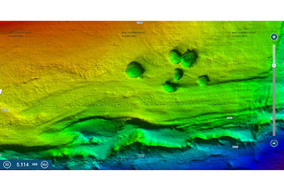
Furuno USA has announced a software update for NavNet TZtouch2 that enables use of the popular CMOR seafloor maps. CMOR’s high-resolution, shaded-relief bathymetric bottom images help navigators identify suitable locations for fishing and diving, overlaid on top of NavNet’s conventional vector, raster, or fishing charts. CMOR’s high-resolution coverage for NavNet TZtouch2 Multi-Function Displays currently includes parts of the Gulf of Mexico, Florida, and southern portions of the East Coast, and additional areas will be available in the coming weeks.
The ability to overlay CMOR maps on the chart type of the customer’s choosing is a unique feature of NavNet TZtouch2. For current TZtouch2 owners, the maps properly formatted for use in TZtouch2 MFD’s are available for download from the Furuno web site at www.FurunoUSA.com, along with the software update and instructions for updating the NavNet TZtouch2 system. For customers new to TZtouch2, all new TZtouch2 MFD’s will now ship with a 256GB Micro SD card that includes all of the CMOR maps available, in addition to the system’s pre-loaded raster and vector charts that include most of the western hemisphere. Customers can unlock the CMOR charts at the time of purchase, or at any time thereafter.
For more information on CMOR maps, visit their website at www.cmormapping.com. To learn more about NavNet TZtouch2, or the complete line of Furuno Marine Electronics, visit: https://furunousa.com

