C-MAP App Introduces Enhanced Chart Quality and Key New Features
June 15, 2021
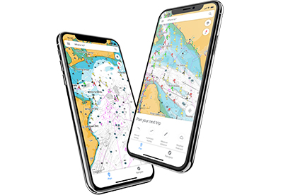
C-MAP®, a leader in digital marine cartography and cloud-based mapping, unveiled its latest app for boaters, anglers, sailors and water-lovers alike this week including a Premium version loaded with new mapping features, more advanced functionality and new shaded relief option, previously only available in C-MAP REVEAL products for chartplotters.
The C-MAP app is free to download and easy to use, delivering subscription-free access to the latest nautical charts along with a range of features including personal waypoints, routes and tracks, weather updates, points of interest, planning tools and many ways to personalize. The C-MAP app can function as the complete solution to your nautical planning and on-water navigation needs, or for those using a chartplotter, it is a great back-up.
The detailed C-MAP cartography has a broad range of uses from the solo kayaker in-shore to large powerboats going out for multiple day trips and everything in between – even the marine hobbyist just exploring the Earth’s bodies of water and waterways in the palm of their hand.
“The latest release of our app has the highest-quality marine maps available with a best-in-class user experience,” said Max Cecchini, executive vice president, C-MAP. “It also comes with a new annual Premium subscription offer which boaters will find easy to understand and an excellent value for a truly Premium experience.”
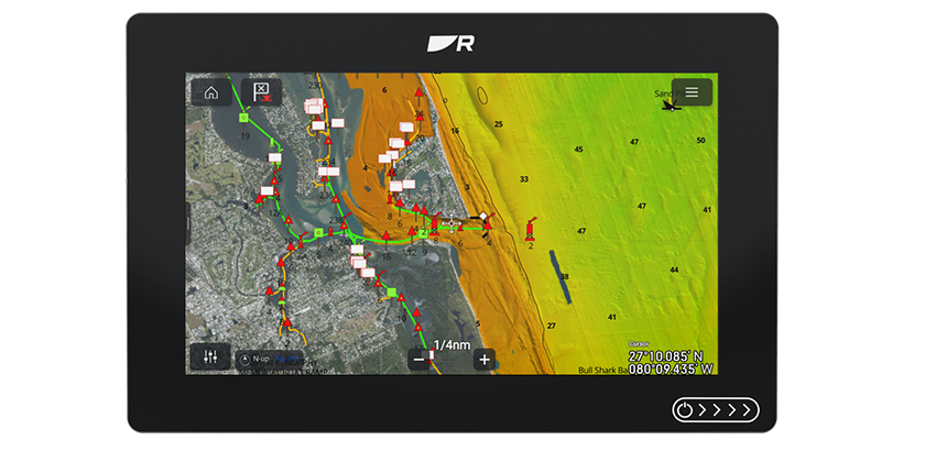
Premium includes all the features available to free users, plus unlimited offline maps downloads, High-Resolution Bathymetry, AIS and C-MAP Traffic, five-day weather along the route and weather overlay, as well as GPS position and full navigation functionality. Premium access also unlocks Custom Depth Shading and – available in early July for the first time in the C-MAP app – global Shaded Relief.
The C-MAP charts are carefully optimized for the app, highlighting the most important data and maintaining accuracy with a clean, uncluttered view. The charts are powered by data from official Hydrographic Offices, with data continuously updated and augmented from thousands of additional data sources, to ensure the latest, most detailed coverage.
Users can plan a route from their computer, tablet or smartphone, and the data will sync across all devices. Then, when they are out on the water, users can save their favorite places to drop anchor or fish and follow the same safe passage every time with the breadcrumb trail that shows up in a personalized map. In addition, boaters can check out thousands of points of interest included in the maps like marinas, harbors, beaches and fuel docks.
“The C-MAP app is already one of the highest-rated marine navigation and planning app’s out there, as our customers love its ease of use and accuracy,” said Cecchini. “Now with new features and a really compelling Premium offering, we’re confident we’ll welcome even more happy boaters to the C-MAP community.”
FREE FOR ALL USERS
View the latest nautical charts
Manual and Autorouting™
GPS Position & Full Navigation
Add Personal Routes & Record Tracks
Add Personal Waypoints
GPX Import & Export
Thousands of Points of Interest
Marine Weather Forecast
Weather Along the Route (24 hours)
Chart Personalization
Measure Distance Tool
PREMIUM FEATURES
Unlimited Offline Maps (Global)
5-Day Weather Along the Route
5-Day Weather Overlay
High-Resolution Bathymetry
Custom Depth Shading
AIS
C-MAP Traffic: View other app users
Coming Soon: Shaded Relief
Download for iOS on Apple Store.
Download for Android on Google Play.
For more information, please visit www.c-map.com.