GARMIN ADDS NEW SIRIUSXM MARINE FISH MAPPINGTM CAPABILITIES TO ITS GXM 54 SATELLITE WEATHER & RADIO RECEIVER
July 23, 2019
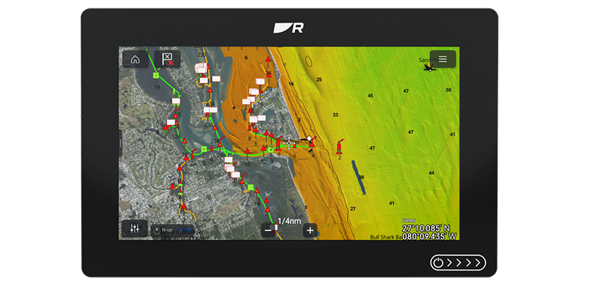
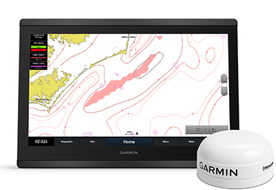
Garmin International, Inc., a unit of Garmin Ltd., has announced that its latest satellite weather & audio receiver, the GXM 54, will support SiriusXM Fish Mapping, the most comprehensive SiriusXM Marine service package designed to help saltwater anglers locate fish faster, saving time and fuel.
In addition to essential weather information provided by SiriusXM, like radar, lightning, marine zone forecasts, wind and wave information, the new Fish Mapping service provides regularly updated, 1, well beyond cellular range. Offering premium marine features like recommended areas to find specific game fish, weed lines, sea surface temperatures and front strength, sub surface sea temperatures, plankton concentration data, and more, the new Fish MappingTM service is ideal for all salt-water anglers who travel offshore – whether they spend a significant amount of time fishing in tournaments, taking clients on charter trips, or just fishing for fun.
SiriusXM Marine’s new Fish Mapping service includes:
Fishing Recommendations
View locations oceanographers recommend to find specific types of game fish, based on their expert analysis. The locations are overlaid on your chart and can be viewed in combination with other features. Updated twice per week.
Weed Lines
View concentrations of floating algae/plants, which provide nutrients and cover, creating habitats for bait fish, shrimp, etc., and attract larger, predatory game fish. Weed lines drift and shift over time, so they can be hard to locate. This feature helps anglers find where weed lines have been sighted recently, or are most likely to be forming. Updated every 24 hours.
Sea Surface Height Anomaly
View locations where the sea surface height is different than the surrounding area using real-time radar data and models of the sea surface. View “upwelling” areas that create favorable conditions including nutrient-rich water that attracts bait fish and game fish and avoid “downwelling” areas that are nutrient poor and don’t support favorable fishing conditions. Updated every 24 hours.
Sea Surface Temperature Contours
View contour lines where there is sea surface temperature change from cool to warm and attracts bait fish. Use these contours to help locate your target species based on their preferred temperature range. Updated every 6 hours.
Sea Surface Temperature Front Strength
View strength of ocean “fronts”, which are significant temperature changes that create distinct boundaries between bodies of water, concentrating nutrients which attracts bait fish. Strong and very strong fronts are good places to find game fish. Updated every 24 hours.
30m Subsurface Sea Temperatures
View the water temperature 30 meters below the surface. This feature allows you to identify areas with the preferred temperature range of your target game fish in the area below the surface where they are likely to be hunting. Updated every 24 hours.
Plankton Concentration Contours
View areas of plankton concentrations. Plankton is the primary food source for most bait fish, which attract hungry game fish. Updated every 24 hours.
Plankton Front Strength
Locate where there are the areas of greatest plankton concentrations with murky, nutrient-rich water favorable for baitfish, next to areas with relatively little/no plankton with clear, predator-preferred water with better visibility for hunting. Updated every 24 hours.
The GXM 54 is easy to install and use, and its reliable antenna provides the best possible reception — even on the fringes of SiriusXM coverage area. The SiriusXM Marine Fish Mapping service will be supported beginning on August 13th with a free chartplotter software update. The SiriusXM Fish Mapping service requires a $99.99 a month subscription, which can be suspended at no charge for up to 6 months each year. For more information, visit garmin.com/marine and siriusxm.com/fishmapping.
Garmin is the world’s leading marine electronics manufacturer2 and was recently named Manufacturer of the Year for the fourth consecutive year by the NMEA, an honor given to the most recognized marine electronics company for support of products in the field. Garmin’s portfolio includes some of the industry’s most sophisticated chartplotters and touchscreen multifunction displays, sonar technology, high-definition radar, autopilots, high-resolution mapping, sailing instrumentation, audio, entertainment and other products and services that are known for innovation, reliability, and ease-of-use. Other Garmin marine brands include FUSION Entertainment, Navionics, a premier supplier of electronic navigation charts, and EmpirBus.
For decades, Garmin has pioneered new GPS navigation and wireless devices and applications that are designed for people who live an active lifestyle. Visit: garmin.com